Home > Local history > Ireland > Kilrea > Letts’s map (1883)
Contents:
Title :
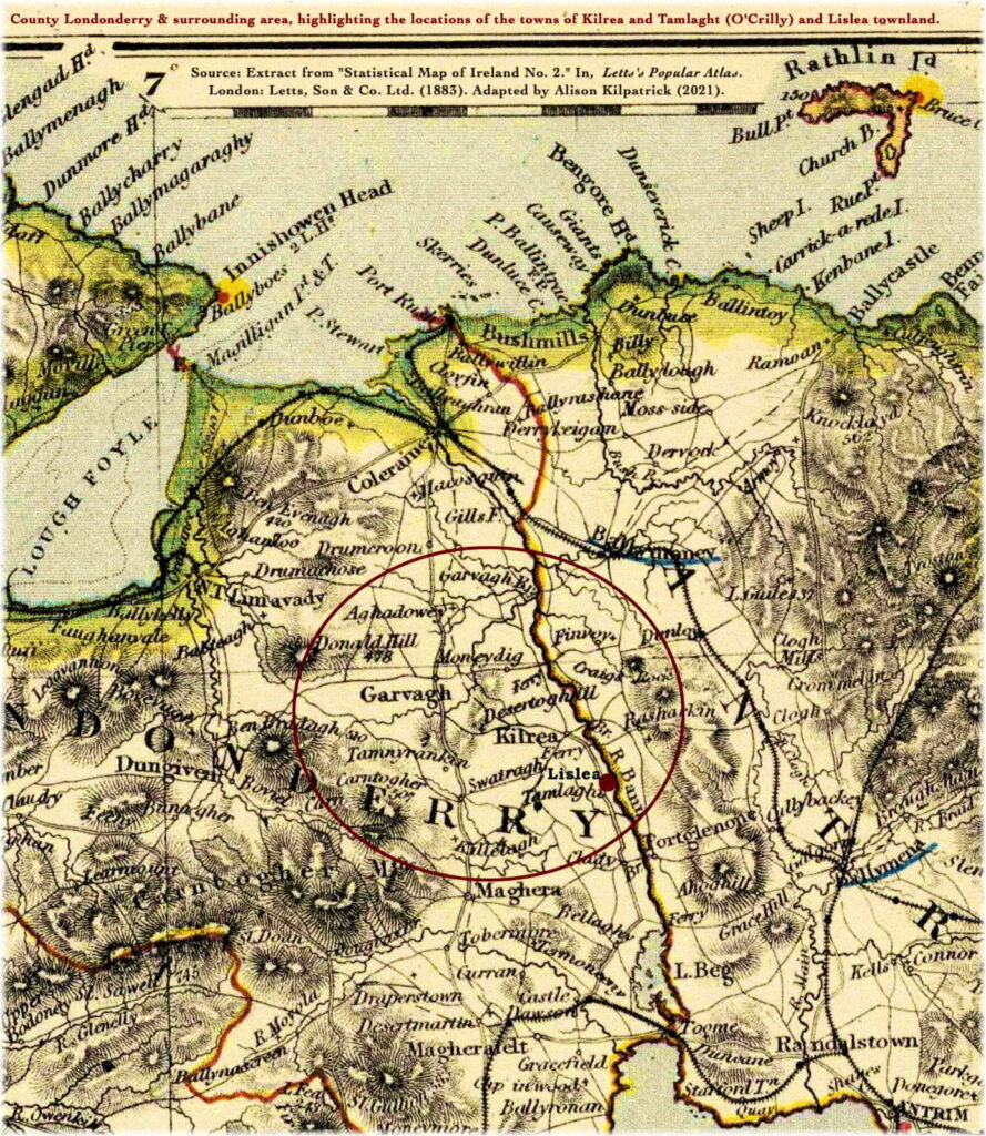
Map (extract) of county Londonderry & surrounding areas, highlighting the mid-eastern section of the county.
Click here to see enlarged map.

Description :
Letts’s map (1883) (partial) of county Londonderry with neighbouring counties of Antrim (part), Donegal (part), and Tyrone (part); highlighting the locations of the towns of Kilrea and Tamlaght (O’Crilly), and of Lislea townland, situated at the mid-point of the River Bann (Upper). Citing Rumsey’s note: “Relief shown by hachures and spot heights. Shows classified cities, old provinces, counties, railroads, cathedral towns, lifeboat stations, lights and lighthouses, round towers, etc.”
Towns and parishes :
The area defined by the red circle, in the map above, shows the general area in which our Kilpatrick / Kirkpatrick, McKay, Gordon, and Campbell families lived. This area contains the following towns and parishes in mid-eastern portion of the county of Londonderry, moving from north to south:
- Garvagh, parish of Errigal
- Aghadowey, parish of Aghadowey
- Donald’s Hill (part), parish of Balteagh (part)
- Moneydig, Desertoghill, and Tamnyrankin, parish of Desertoghill
- Kilrea town and Lislea townland, parish of Kilrea
- Tamlaght village, parish of Tamlaght O’Crilly
- Swatragh, parish of Maghera (part)
- Carntogher mountain and Killelagh village, parish of Killelagh
Eastwards, across the river Bann, lie the following towns and parishes in the county of Antrim (again, within the red circle):
- Rasharkin village, parish of Rasharkin
- Craigs, in the parish of Finvoy
- Vow, unmarked, but also in the parish of Finvoy, lying on the eastern bank of the river Bann about 2.5 miles north of the town of Kilrea
Scale:
Driving distance from Kilrea to: Garvagh, 5.9 miles; Maghera, 9.1 miles; Coleraine, 15.3 miles.
Source:
Letts & Co. Ltd. Extract from “Statistical Map of Ireland. No. 2.” In, Letts’s Popular Atlas, being a series of maps delineating the whole surface of the globe, with many special and original features; and a copious index of 23,000 names. Complete edition. London: Letts Son & Co. Limited, 33, King William Street, London Bridge, E.C. Factory and works at New Cross, S.E. 1883. Online at David Rumsey’s Map Collection ![]() . Adapted by Alison Kilpatrick (2021).
. Adapted by Alison Kilpatrick (2021).
End notes :
Source citation for this page: Arborealis. “Lett’s map (1883) of Kilrea, Lislea, and Tamlaght, County Derry.” Online at Arborealis, arborealis.ca/local-history/ireland/kilrea/letts-map-1883/, accessed [insert date].
All rights reserved. Alison Kilpatrick ©2021.
Updated 15th Oct. 2023; edited 29th Dec. 2023.