Home > Family history > Ireland > Burke of Kilcolman > Townland map, Kilcolman (Clanmorris) in Griffith’s Valuation, 1856
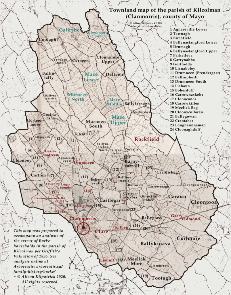
This page displays a map of the parish of Kilcolman in the county of Mayo. The map highlights Burke households surveyed by Griffith’s ordnance survey team in 1856. For reference, this parish comprises eighty-three townlands, covering 23,744.4 acres or 37.1 square miles (96.1 square kilometres). It is surrounded by the following parishes, in clockwise fashion: on the north: Killedan; the northeast: Knock; the southeast: Bekan; south-southeast: Kilvine; south and southwest: Crossboyne; and west: Mayo.
Key:
- Townlands with green-coloured labels = held in fee by Isidore Burke
- Townlands with red-coloured labels = other townlands with Burke or Bourke households
This map should be consulted with the accompanying table ![]() which lists these households, and analysis and remarks
which lists these households, and analysis and remarks ![]() .
.
 , county Mayo. Adapted from the digital image online at AskAboutIreland
  askaboutireland.ie (accessed 5th Jan. 2021).
Click on image to see enlarged version of this map in new tab.
Source of 2nd Ordnance Survey:—Griffith, Richard. General Valuation of Rateable Property in Ireland. “County of Mayo. Valuation of the Several Tenements in the Union of Claremorris.” Citing extracts for the parish of Kilcolman. Dublin: Alex. Thom and Sons, 1856.
See also :
- Burke households in Kilcolman per Griffith’s Valuation, 1856
- Analysis of Burke tenants and lessors in the parish of Kilcolman (Clanmorris) per Griffith’s Valuation (in progress)
- Extent of the surnames Burke/Bourke in the county of Mayo, 1856/57
End notes :
Source citation for this page: Kilpatrick, Alison. “Townland map, parish of Kilcolman (Clanmorris), 1856.” Chapter in the family history research completed for the Burke surname occurring in the parish of Kilcolman (Clanmorris), county Mayo. Adapted from the digital image online at AskAboutIreland ![]() askaboutireland.ie (accessed 5th Jan. 2021). Published to Arborealis, online at arborealis.ca/family-history/irish/burke/townland-map-kilcolman/, accessed [insert date].
askaboutireland.ie (accessed 5th Jan. 2021). Published to Arborealis, online at arborealis.ca/family-history/irish/burke/townland-map-kilcolman/, accessed [insert date].
All rights reserved. Alison Kilpatrick ©2021.
Updated 1st Nov. 2023; edited 27th Dec. 2023.